
Čutekryú·kę / Čustekyerhyáʔkę
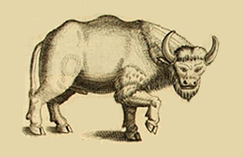
Long ago, our people hunted Čutekryú·kę or Čustekyerhyáʔkę, more commonly known today as bison or buffalo. Like the great herds of the plains, they faced severe population decline due to over hunting, habitat loss, and would see an eventual extinction within North Carolina with the last known one being shot in 1799 by settler Joseph Rice.
1540
John Henry Preston in Western North Carolina: A History (Asheville: Daughters of the American Revolution, 1914) notes that some of Hernando de Soto’s men exploring this area in 1540 were presented with a dressed buffalo skin by the Cherokees. This, Arthur speculates, was perhaps the first such skin “ever obtained by white men.” The Spaniards described it as “an ox hide as thin as a calf’s skin, and the hair like a soft wool between the coarse and fine wool of sheep.”
1612
In 1612, Sir Samuel Argoll (who forced peace on the Powhatan by kidnapping Pocahontas, one of the daughters of Wahunsunacawh) came to Virginia with his superior, Thomas West, 3rd Baron De La Warr. Argoll was mapping Chesapeake Bay with Powhatan guides when he countered bison.
“As soon as I had unladen this corne, I set my men to the felling of Timber, for the building of a Frigat, which I had left half finished at Point Comfort, the 19. of March: and returned myself with the ship into Pembrook [Potomac] River, and so discovered to the head of it, which is about 65 leagues into the Land, and navigable for any ship. And then marching into the Countrie, I found great store of Cattle as big as Kine, of which the Indians that were my guides killed a couple, which we found to be very good and wholesome meate, and are very easie to be killed, in regard they are heavy, slow, and not so wild as other beasts of the wildernesse.”
1709
Two centuries earlier, North Carolina was home to a robust number of bison. In 1709, English naturalist and explorer John Lawson described North Carolina as having “Plenty of Buffalos” in his A New Voyage to Carolina.
1729
A few decades later, Irish-born explorer John Brickell included an illustration of a “Buffello” in his Natural History of North Carolina. Brickell describes Native Americans’ many uses for the buffalo, including for food, bedding, clothing and housewares.
1729
While helping to run the dividing line between North Carolina and Virginia in 1729, Col. William Byrd of Virginia recorded several buffalo sightings in the Piedmont sections of those states. According to Hornaday, Byrd noted that a bull “was found all alone, tho Buffaloes Seldom are,” and “the meat is spoken of as ‘a Rarity.’”
1748
Writing in 1748, German explorer and botanist Pehr Kalm noted, “The wild Oxen have their abode principally in the woods of Carolina, which are far up in the country. The inhabitants frequently hunt them, and salt their flesh like common beef, which is eaten by servants and the lower classes of people.”
1799
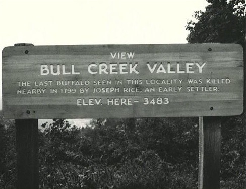
Bison disappeared from North Carolina almost a century before they were wiped out in the American West. Joseph Rice, an early settler of the Swannanoa Valley around Bull Creek, is known for shooting that area’s last buffalo in 1799. A plaque at milepost 373 of the Blue Ridge Parkway marks the location.
1919
On January 30, 1919 the French Broad Hustler reported the shipment of “six head of buffalo –three males and three females –to Hominy, Buncombe County” by the American Bison Society. Their arrival in North Carolina marked the reintroduction of America’s largest big game animal to the state. The experiment was short-lived. Despite the birth of two calves and the addition of bred heifers and a bull, only two members of the herd remained a decade later. The reestablishment of bison into the wild in North Carolina was a failure.
2016
President Obama signed the National Bison Legacy Act into law on Monday, May 9, 2016
Today
Bison in North Carolina can only be observed in designated locations, such as the North Carolina Zoo in Asheboro and various bison farms scattered throughout the state. These places provide opportunities for people to witness and gain knowledge about these magnificent creatures.
The North Carolina Zoo, situated in Asheboro, is a popular destination where visitors can observe bison. Within the zoo, the Prairie exhibit offers a spacious and naturalistic habitat for a bison herd. This allows visitors to observe these animals up close and learn about their behavior, conservation initiatives, and the significance of bison in the history of North America.
Apart from the zoo, several bison farms across North Carolina raise bison for different purposes, including meat production, breeding programs, and educational outreach. Some of these farms may offer guided tours or public viewing opportunities, allowing visitors to experience the presence of bison in a farm-like environment.
Buffalo name locations in North Carolina
Dutch Buffalo Creek
Buffalo Creek
Back Creek rises in w Orange County and flows sw into Alamance County, where it enters Haw River. Appears on the Moseley map, 1733, as Buffalo Creek.
Beaver Creek rises in ne Cabarrus County and flows s into Dutch Buffalo Creek about 2 mi. n of town of Mount Pleasant.
Bee Knob , at the head of West Buffalo Creek in w Graham County.
Big Buffalo Creek rises in central Lee County and flows nw into Deep River.
Big Knob , s Watauga County on the head of Buffalo Creek.
Big Lick, community in sw Stanly County. Inc. 1879; charter repealed 1919. Named because salt in the ground attracted deer and buffalo. See also Oakboro.
Blackwater Run rises in s Rowan County and flows s into n Cabarrus County, where it enters Dutch Buffalo Creek. The last Indians in Cabarrus County lived along the stream.
Buffalo , community in ne Cherokee County at the mouth of Gipps Creek.
Buffalo , community in ne Stokes County near the head of Buffalo Creek.
Buffalo Branch rises in w Johnston County and flows s into Middle Creek.
Buffalo Branch rises in s Wake County and flows s into w Johnston County, where it enters Middle Creek.
Buffalo Branch rises in w Warren County and flows s into Shocco Creek. Mentioned in local records as early as 1764.
Buffalo City , community on the mainland, w Dare County. Settled 1888. Named for Buffalo City Mills, former sawmill there. Alt. 10.
Buffalo Cove , community in n Caldwell County. Named for the cove in which many buffalo were killed. Settled late eighteenth century.
Buffalo Creek rises in nw Anson County and flows e into Pee Dee River.
Buffalo Creek rises near Bluff Mountain in se Ashe County and flows ne into North Fork New River.
Buffalo Creek rises in n Caldwell County and flows s into Yadkin River.
Buffalo Creek rises in n Cleveland County and flows sw through Cleveland County into South Carolina, where it enters Broad River.
Buffalo Creek rises in nw Cleveland County and flows sw into Rutherford County, where it enters Brier Creek.
Buffalo Creek rises in ne Davie County and flows sw approx. 3 mi. into Dutchman Creek about 4 mi. from its mouth in the Horseshoe of Yadkin River.
Buffalo Creek rises in n Forsyth County and flows ne into s Stokes County, where it enters Town Fork Creek.
Buffalo Creek rises in central Franklin County and flows sw into Tar River.
Buffalo Creek rises in n Franklin County and flows se into Sandy Creek. Buffalo Creek rises in nw Franklin County and flows ne into Tar River.
Buffalo Creek is formed by the junction of North Buffalo Creek and South Buffalo Creek in ne Guilford County. It flows ne into Reedy Fork Creek. Named after 1755 but before 1758.
Buffalo Creek rises in sw Harnett County and flows s into e Moore County (formerly Hoke County), where it enters Little River.
Buffalo Creek rises in w Hoke County and flows sw into Lumber River.
Buffalo Creek rises in w Moore County and flows ne into Deep River.
Buffalo Creek rises in ne Orange County and flows se into Durham County, where it enters North Fork Little River.
Buffalo Creek rises in n Richmond County and flows sw into Little River.
Buffalo Creek rises in nw Rutherford County and flows s into Broad River.
Buffalo Creek rises in e Stokes County and flows into Rockingham County and into Mayo River.
Buffalo Creek rises in ne Stokes County and flows ne into Rockingham County, where it enters Mayo River.
Buffalo Creek rises in s Union County and flows sw into South Carolina, where it enters Lynches Creek.
Buffalo Creek rises in s Vance County and flows s into Tar River. Water-ground corn meal is produced commercially on the creek.
Buffalo Creek rises in e Wake County and flows se into Johnston County, where it enters Little River.
Buffalo Creek rises in s Warren County and flows s into Fishing Creek.
Buffalo Creek rises in s Watauga County and flows se into Caldwell County.
Buffalo Creek . See Back Creek.
Buffalo Creek . See Irish Buffalo Creek.
Buffalo Creek . See Warrensville.
Buffalo Ford, community in se Randolph County served by post office, 1850–1904. Known as Buffaloford after 1894.
Buffaloford . See Buffalo Ford.
Buffalo Island , swampy land formation on Potecasi Creek in central Hertford County.
Buffalo Island Creek rises in n Rockingham County and fl ows se into Dan River.
Buffalo Knob , a stony elevation on the Cleveland-Lincoln county line.
Buffalo Lake , w Harnett County on the headwaters of Reedys Swamp. Approx. ½ mi. long. Alt. 293.
Buffalo Race Path . See Bute County.
Buffalo Shoals Creek rises in w Iredell County and flows s into Catawba River.
Bull Creek rises in n Buncombe County near Bull Mountain and flows s into Swannanoa River. The last buffalo seen in the county was killed by one of the first white settlers in the vicinity, Joseph Rice.
Bute County was formed from Granville County in 1764; named in honor of John Stuart (1713–92), Earl of Bute, who until his resignation in 1763 had been First Lord of the Treasury. The county was divided in 1779 to form Franklin and Warren Counties. The courthouse was ordered to be built on Jethro Sumner’s land at a place called Buffalo Race Path; the site is in Warren County approx. 6 mi. se of Warrenton. See also St. John’s Parish, Granville County
Caves, The , natural subterranean caves in nw Rutherford County between Broad River and Buffalo Creek in Rumbling Bald Mountain, which see .
Deep Gap , central Graham County in Cheoah Mountains at the head of East Buffalo Creek
Deerlick Ridge extends e from West Buffalo Creek to Snowbird Creek in s Graham County.
Dry Pond Gap , s Watauga County between the heads of Storey Creek, Buffalo Creek, and Joe Creek
Dutch Buffalo Creek rises near Organ Church in se Rowan County and fl ows se through Cabarrus County into Rocky River. Named for the “Pennsylvania Dutch” (German, Deutsch ) who settled there. See also Irish Buffalo Creek.
East Buffalo Creek rises in central Graham County and flows sw into Santeetlah Lake
Elberon , community in s Warren County between Lees Branch and Buffalo Branch. Post office est. in 1897 but discontinued in 1954.
Flat Branch rises in s Watauga County and flows se into Buffalo Branch.
Georgeville , community in se Cabarrus County at junction of Dutch Buffalo Creek and Rocky River. Named for George Shinn; formerly known as Shinnville. See also Reed Gold Mine
Grove Hill , community in s Warren County e of Buffalo Creek and s of Reedy Creek. Settled prior to 1800; post office est. 1828 but discontinued in 1954. In 1840 the post office name was temporarily changed to Owens Store. See also Fontena
Hillside Branch rises in s Watauga County and flows se into Buffalo Branch.
Honeycutt Mine , former gold mine on Little Buffalo Creek, ne Cabarrus County.
Irish Buffalo Creek rises in sw Rowan County and flows s into Cabarrus County, where it enters Coldwater Creek. Called Buffalo Creek on the Collet map, 1770, but Irish Buffalo Creek on the Price map, 1808. Named for Scots-Irish settlers. See also Dutch Buffalo Creek.
Isenhour Mine , former gold mine in ne Cabarrus County on Little Buffalo Creek
Joel Ridge , nw Rutherford County, extends e from the head of Buffalo Creek.
Joe’s Fork rises in s Watauga County and flows se into n Caldwell County, where it enters Buffalo Creek.
Kittrell , town in sw Vance County between Long Creek and Buffalo Creek. Alt. 372. Inc. 1885 and named for George Kittrell, who donated land for a railway station there. Confederate cemetery is there. Nearby Kittrell’s Springs, which see , is said to have been the fi rst summer resort in the state. Before the incorporation of the town, the community was known as Staunton. Served by post offi ce since 1854. Kittrell College, est. 1886, was there. See also Epping Forest
Lake Lure , town in w Rutherford County on the lake of the same name. Est. 1925; inc. 1927. Alt. 1,050. The town has an immense corporate limit situating it on Buffalo Creek, Broad River, and Pool Creek
Little Bear Creek rises in ne Cabarrus County and flows sw into Dutch Buffalo Creek.
Little Buffalo Creek rises in e Johnston County and flows se into Little River
Little Buffalo Creek rises in central Lee County and flows n into Deep River.
Little Buffalo Creek rises in sw Lincoln County and flows sw into Cleveland County, where it enters Buffalo Creek.
Little Buffalo Creek rises in nw Richmond County and flows sw into Buffalo Creek.
Little Buffalo Creek rises in s Rowan and n Cabarrus Counties and flows sw into Dutch Buffalo Creek.
Little Buffalo Creek rises in s Vance County and flows sw into Buffalo Creek.
Little Buffalo Creek . See West Buffalo Creek.
Long Creek rises in the town of Kings Mountain in se Cleveland County and flows se into Buffalo Creek.
Marks Pond , approx. ½ mi. long, se Harnett County on Buffalo Creek.
Marshbourns Pond , in e Wake County on Buffalo Creek.
Meadow Branch rises in n Moore County and flows ne into Buffalo Creek.
Mitcheners Pond , w Franklin County on Buffalo Creek. Formed in 1907. Covers 50 acres, with a max. depth of 12 ft.
Mount Pleasant , town in e Cabarrus County. Alt. 630. Settled about 1750 by Germans from Pennsylvania. Inc. 1859. Took its name from its elevated site between Buffalo Creek and Adams Creek. Former home of 2 Lutheran Synod church schools: Mount Pleasant Collegiate Institute (male) and Mount Amoena Seminary (female).
Mount Pleasant , community in se Moore County between Crains Creek and Buffalo Creek
Muddy Fork rises in e Cleveland County and flows sw into Buffalo Creek.
North Buffalo Creek rises in central Guilford County and flows ne through the city of Greensboro to join South Buffalo Creek in forming Buffalo Creek in ne Guilford County.
Old Field Creek rises in n Caldwell County and flows ne into Buffalo Creek.
Ollie Branch rises in central Graham County and flows sw into East Buffalo Creek.
Perrys Pond , in ne Wake County on Buffalo Creek. Formed in 1910, covers 20 acres, with a max. depth of 10 ft. Open to the public; used for recreation.
Persimmon Creek rises in central Lee County and flows n into Big Buffalo Creek.
Potts Creek rises in se Cleveland County and flows nw into Buffalo Creek
Red Branch rises in e Cabarrus County and flows e into Dutch Buffalo Creek.
Roberts Branch rises in s Cleveland County and flows e into Buffalo Creek. Named for “Squire Billy” Roberts, owner of the land through which it ran.
Robertsons Pond , e Wake County on Buffalo Creek. Formed in 1900. Covers 65 acres, with a max. depth of 15 ft. Used for recreation and as power source.
Sandy Ridge , community in n Stokes County near Buffalo Creek.
Schene Wolf Creek rises near Organ and Lower Stone Churches approx. 5 mi. sw of Rockwell, se Rowan County, and flows s into ne Cabarrus County, where it enters Dutch Buffalo Creek. Probably named by early German settlers, Schene being derived from schön (beautiful). Sometimes also called Jennie Wolf Creek.
Skunk Creek rises in central Lee County and flows nw into Big Buffalo Creek.
South Buffalo Creek rises in s central Guilford County and flows ne to join North Buffalo Creek in ne Guilford County to form Buffalo Creek.
South Lowell , community in nw Durham County between Buffalo and Horse Creeks on the n side of North Fork Little River.
Spanish Oak Branch rises in n Watauga County and flows s into Buffalo Branch.
Squally Creek rises in w Graham County and flows e into West Buffalo Creek.
Stubbs , community in e Cleveland County on Buffalo Creek. Alt. 950. Settled about 1885. Named for Col. Seth W. Stubbs, who made the clock for the Lincoln County Courthouse, 1856
Swopes Branch rises in e Cabarrus County and flows se into Little Buffalo Creek.
Tiger , community in nw Rutherford County on Buffalo Creek.
Trickum Creek rises in n Forsyth County and flows n into Buffalo Creek.
Trinity , community in s Union County on Buffalo Creek; named for a local church. Former Hope community was located just e.
Warrensville , town in central Ashe County. Inc. 1931, but not now active in municipal affairs. Settled about 1826 and known as Buffalo Creek until renamed for the builder of first gristmill and sawmill.
West Buffalo Creek rises in sw Graham County and flows ne into Hooper Mill Creek. Also known as Little Buffalo Creek.
West Buffalo Creek rises in sw Graham County and flows ne into Hooper Mill Creek. Also known as Little Buffalo Creek
Whitaker Creek rises in e Cleveland County and flows s into Buffalo Creek.
White Rock Ridge , s Watauga County, extends nw from Hillside Branch w of Buffalo Creek.
Whitney Mines , former gold mine in ne Cabarrus County on Little Buffalo Creek.
Wolfden Branch rises in s Watauga County and flows sw into Buffalo Creek.
Youngs Mountain , nw Rutherford County, extends ne parallel to Buffalo Creek. Alt. approx. 2,700.